See Every Drone.
Transmit Nothing.
AISAR is a passive radar mesh platform that detects, classifies, and locates drones by analyzing their RF emissions — without transmitting a single signal. No spectrum licensing. No emissions. Immediate deployment across the EU.
Europe's Airspace Is Under Attack.
Most Infrastructure Has No Protection.
Airport shutdowns. Energy facility overflights. Border incursions. The EU CER Directive mandates detection by 2027. Less than 5% of critical infrastructure is covered.
AISAR Passive Radar Mesh: Detect. Classify. Locate.
A modular, AI-powered passive radar platform. Each AISAR node listens to the electromagnetic spectrum without transmitting. Multiple nodes form a self-healing mesh that triangulates threats with sub-meter accuracy. Deployable in minutes. Scalable from a single point to a 25+ km² coverage network.
Passive RF / SIGINT Detection
Detects drone controller links, video transmission, telemetry, and proprietary protocols (DJI OcuSync, FHSS). Classifies 37+ drone types from RF fingerprints using trained CNN models. Covers 900 MHz – 5.8 GHz. No emissions. No spectrum licensing.
Reflected Signal Analysis
Detects drones that don't transmit. Phase 2 analyzes reflected Wi-Fi, GPS, 5G, and broadcast signals bouncing off aerial objects. Bistatic/multistatic radar geometry enables range-Doppler analysis of RF-silent targets — including autonomous and pre-programmed drones.
Mesh Network Architecture
3, 5, 7+ AISAR units form a self-organizing mesh. TDOA/FDOA triangulation for sub-meter geolocation. Cross-node signal correlation for velocity and heading. Redundant coverage with no single point of failure. 5 nodes cover 25+ km².
AI-Powered Edge Processing
Every node runs classification AI locally on NVIDIA Jetson AGX Orin. No cloud. No latency. FFT → Spectrum Monitor → CFAR Detection → CNN Classification. 340 signals/sec. 99.7% binary detection accuracy. Self-improving models.
From RF Signal to Threat Alert in Milliseconds
Place AISAR nodes at your perimeter. Each unit is self-contained: SDR antenna array, edge compute, rugged enclosure, GPS/PPS synchronization, mesh radio. No infrastructure required. Power on and the mesh auto-configures.
Nodes continuously scan the RF spectrum across all commercial drone bands. The Spectrum Environment Monitor builds a baseline of your local electromagnetic environment, then flags anomalies — reducing false positives by 5–15× compared to traditional detection.
Detected signals are classified in real-time by a three-level CNN: Is it a drone? What type of transmitter? What specific model? The system identifies 37+ drone types from RF fingerprints alone — including DJI, Autel, FPV racing drones, and custom-built platforms.
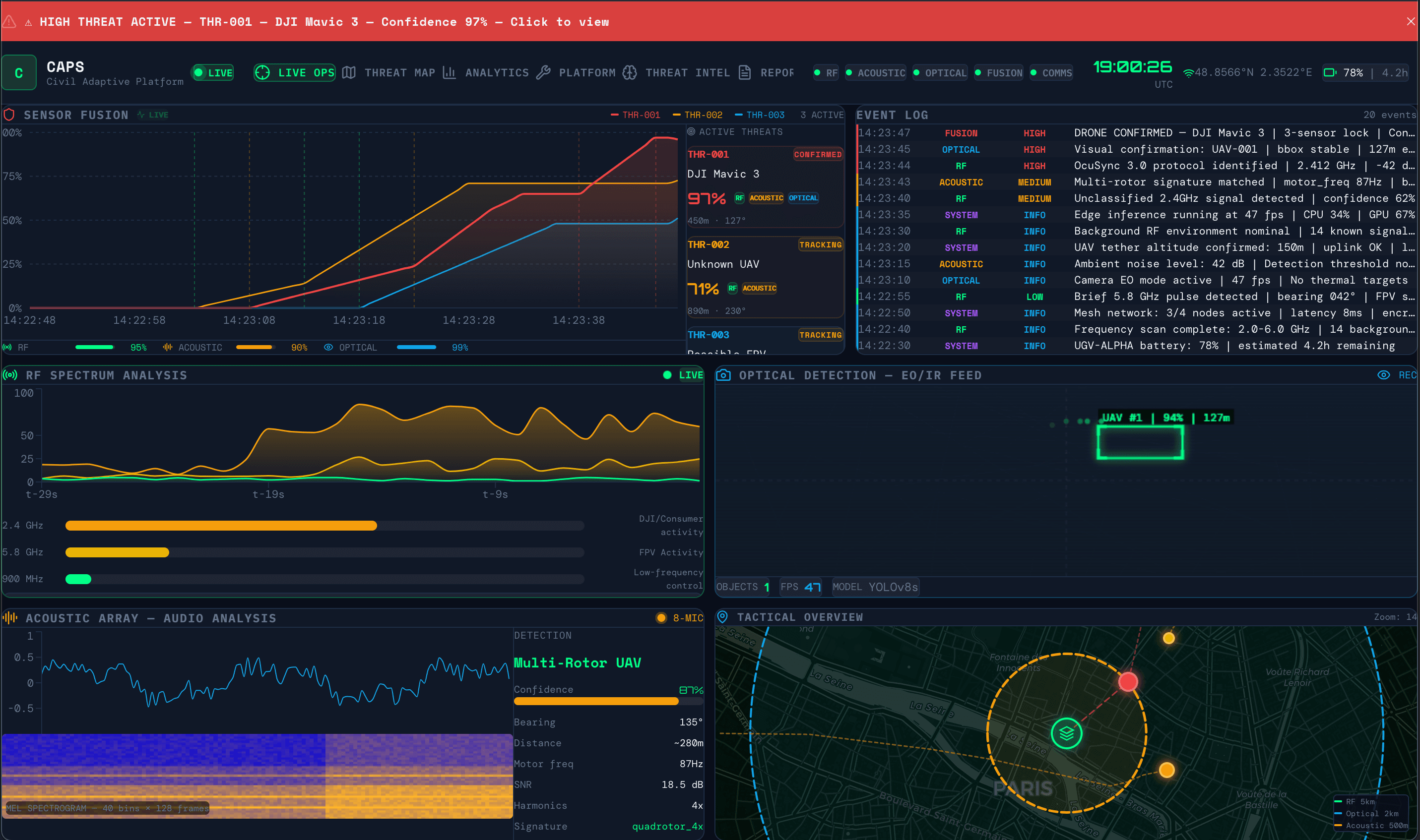
Multiple nodes correlate time-of-arrival data to triangulate the drone's position, heading, speed, and altitude. Results appear on the AISAR Fusion Dashboard within milliseconds. Operators see the threat on a map with classification, confidence level, and track history.
AISAR Fusion Dashboard.
Full Situational Awareness.
A real-time C2 interface for managing your entire AISAR mesh. See every detection, every node, every signal — on one screen.
What Makes AISAR Different
Completely Passive
Zero emissions. Zero licensing. Deploy anywhere in the EU without regulatory approval. Your detection network is invisible to the threats it monitors.
Mesh-Native Architecture
Not a single sensor retrofitted with networking. AISAR was designed from day one as a distributed mesh. Each node is autonomous. The network gets smarter with every unit added.
AI-Classified, Not Just Detected
Other systems tell you 'something is there.' AISAR tells you 'DJI Mavic 3 Pro, FPV mode, 2.4 GHz, bearing 247°, 1.2 km, closing at 14 m/s.' That's the difference between an alarm and intelligence.
Edge-Autonomous
No cloud. No backhaul. No single point of failure. Every node processes locally on NVIDIA Jetson AGX Orin. Critical for degraded environments, disaster zones, and classified operations.
Tested in Ukraine. Engineered in the EU.
Detection algorithms validated on the largest real-world operational RF dataset in Europe — gathered in the most drone-intensive environment in history. Engineered in Zaragoza, Spain.
Two Phases, Full Spectrum Coverage
Phase 1 (shipping now): direct signal detection — controller links, video, telemetry. Phase 2 (2027): reflected signal analysis — Wi-Fi, GPS, 5G reflections off drone surfaces.
Built Faster. Tested Deeper. Optimized by AI.
AISAR isn't just a radar product. It's an entire AI-powered development ecosystem. Our Radar Digital Twin and AI Optimization Core mean we develop detection systems in weeks, not years — and every unit we ship has been tested against 10,000+ simulated scenarios.
A full digital replica of the AISAR antenna array and signal processing chain. Simulate RF environments, drone signatures, interference patterns, and mesh network behavior — all in software.
Bayesian optimization finds optimal antenna geometry, signal processing parameters, and classification model architectures in a fraction of the time traditional R&D requires.
AISAR vs. Existing Solutions
| FEATURE | AISAR | LEGACY FIXED SENSORS | MILITARY SYSTEMS |
|---|---|---|---|
| Passive RF Detection | ✓ | ✓ | ✓ |
| Reflected Signal (WiFi/GPS) | ✓ (Phase 2) | ✗ | Partial |
| Mesh Scalable | ✓ Native | ✗ | Custom integration |
| AI Classification (37+ drones) | ✓ | Limited | ✓ |
| Edge Processing (No Cloud) | ✓ | Cloud-dependent | ✓ |
| Digital Twin Simulation | ✓ | ✗ | ✗ |
| Deployable in Minutes | ✓ | Fixed-site | Hours/days |
| Approximate Unit Cost | From €100K | €100–300K | €500K+ |
No solution on the market combines passive RF + reflected signal + mesh network + digital twin simulation + edge AI in a single deployable platform.
Protecting What Matters
Airports & Aviation
Meet EASA counter-drone mandates. Protect approach paths and runways. Integrate with existing ATC systems. CER Directive compliant incident logging. Deploy a perimeter mesh around your airport in hours, not months.
Energy & Critical Infrastructure
Power plants, substations, wind farms, LNG terminals. Persistent drone surveillance without manned security patrols. Edge processing means no network dependency — critical for remote sites.
Law Enforcement & Border Security
Guardia Civil. Gendarmería. Bundespolizei. Mobile mesh deployment for events, VIP protection, border monitoring. Passive detection means no interference with existing communications.
Defense Integrators & System Primes
Integrate AISAR as the passive RF layer in your multi-sensor C-UAS architecture. Open API. Modular. Software-defined. Replace or complement existing RF detection with a mesh-native, AI-classified solution.
Tested in Ukraine.
Engineered in the EU, Spain.
AISAR was born from necessity. Our team developed and tested drone detection algorithms in Ukraine — the most drone-intensive environment in history. Millions of drone sorties. Every electronic warfare scenario. Real RF signatures from real threats, not lab simulations.
We brought that intelligence to Europe. AISAR is engineered, manufactured, and supported through our EU operation in Zaragoza, Spain — with technology partnerships across the European defense ecosystem. The platform meets EU sovereignty requirements. No ITAR dependencies. No non-European supply chain risk.
The result: a passive radar platform validated on data no competitor can access, built to European standards, and ready to deploy across the continent.
From Pilot to Full Coverage
Single-site coverage. Ideal for evaluation and proof of concept. Includes AISAR Fusion Dashboard, deployment support, and 90-day AI model tuning.
Full-site perimeter coverage. Triangulation-grade geolocation. Redundant mesh with self-healing topology. Suitable for airports, energy sites, and border sectors.
Multi-site deployment. Centralized C2 across distributed locations. API integration with existing security infrastructure. Dedicated account engineering. Custom AI model training.
See AISAR in Action
Whether you're protecting an airport, securing critical infrastructure, or integrating passive detection into a larger system — let's talk.
andrey@aisar.tech · aisar.tech
EU OFFICE: ZARAGOZA, SPAIN · R&D: KYIV, UKRAINE